For Offical and Accurate school zone information please go to the following website https://nzschools.tki.org.nz/
For the most accurate results, you should select "address" as the search method, then put in your address details and the schools will come up, rather than selecting the school.
BROWNS BAY SCHOOL
Enrolment Scheme Description
Effective from 11 February 2023
The guidelines for development and operation of enrolment schemes are issued under section 11G (3) of the Education Act 1989 for the purpose of describing the basis on which the Secretary’s powers in relation to enrolment schemes will be exercised.
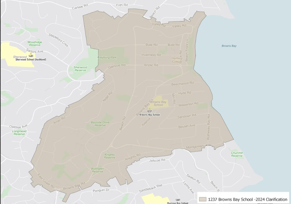
Home Zone
All students who live within the home zone described below (and shown on the attached map) shall be eligible to enrol at the school.
Starting at the intersection of East Coast Road and Browns Bay Road, travel northwest along East Coast Road (even addresses 616-646, odd addresses 525-559 included) to Arran Road. Follow Arran Road northeast, onto Nigel Road and then right onto Glencoe Road (addresses 30, 43 and below included). From 43 Glencoe Road, travel north across Freyburg Park to Woodlands Crescent. Continue north along Woodlands Crescent to Carlisle Road. Travel east along Carlisle Road (addresses 12, 15 and below included), onto Beach Road (even addresses 554-830 and odd addresses 577-831 included), and then continue east onto Valley Road and Manly Esplanade. Follow the coastline south through Browns Bay and Rothesay Bay, stopping at 115 Churchill Road (included). From 115 Churchill Road, travel west
along Montgomery Avenue, onto Beach Road again, through to Knights Road, and continue west along Browns Bay Road back to the starting point.
All residential addresses on included sides of boundary roads and all no exit roads off included sides of boundary roads are included in the zone unless otherwise stated.
Below is a map of our school zone that should be used as a GUIDE ONLY